


How to Enhance Leica TRK Systems with Advanced Imaging Solutions
- 5 min
Table of Contents
Introduction
In the demanding fields of professional surveying and engineering, staying ahead requires leveraging the best available technology. While the Leica TRK system is a powerful tool, the evolving landscape demands more comprehensive visual insights. Standard TRK data, while precise, can lack the visual context needed to fully assess site conditions or communicate findings effectively. How can Leica TRK systems be elevated with first-to-market advanced imaging solutions to meet these growing needs without replacing the core investment?
This article explores how integrating imaging extensions can transform Leica TRK capabilities, ensuring operators are equipped with cutting-edge technology for today’s complex projects and gain a competitive advantage. Pinpointing critical structural weaknesses or energy leaks before they escalate becomes achievable through these enhancements.
Horus’ co-created Leica TRK integration features next-generation edge computing to eliminate field bottlenecks while supporting multiple data formats and API integration.
Understanding the Evolving Needs in Surveying
Standard data capture often falls short when faced with modern project requirements demanding rich visual context alongside precise measurements. There’s a growing need for:
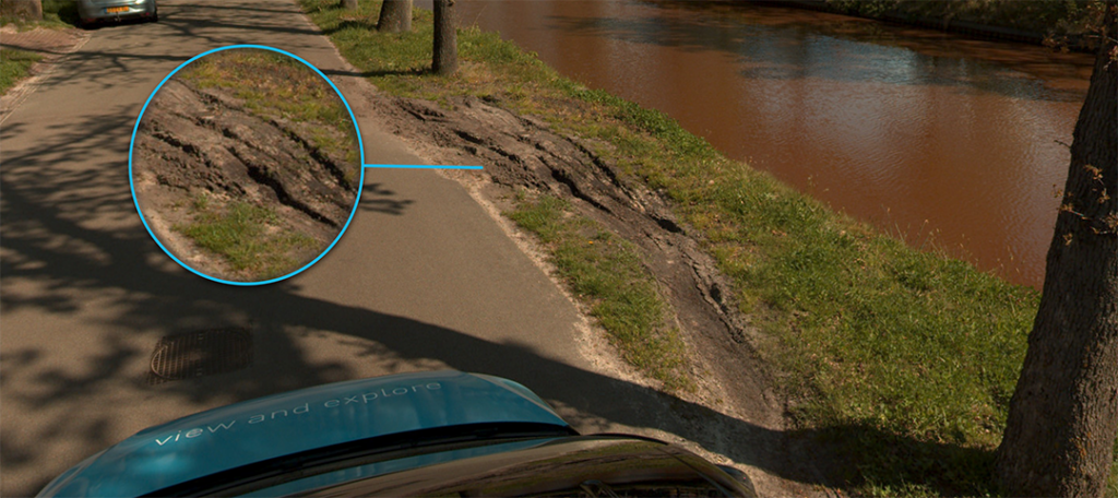
- Comprehensive Visual Documentation: Capturing complete, high-resolution visual records of sites, infrastructure, and construction progress for thorough documentation and detailed analysis.
- Detailed Infrastructure Assessments: Moving beyond surface checks to identify subtle defects, wear patterns, and potential issues that require comprehensive visual evidence for verification.
- Specialized Thermal Analysis: Detecting hidden problems like energy loss, moisture intrusion, and overheating components that remain invisible to conventional inspections and human observation.
Meeting these demands requires extending the capabilities of standard mobile mapping systems like the Leica TRK.
Exploring High-Resolution Imaging: Capturing the Full Picture
Integrating a high-resolution panoramic camera, such as the Teledyne FLIR Ladybug6 (72MP), directly addresses the need for comprehensive visual data. This extension offers significant advantages:
- Effortless Automatic Data Acquisition: Streamlining the capture process with data synchronization that collect vast amounts of high-quality visual data efficiently alongside precise TRK positioning technology.
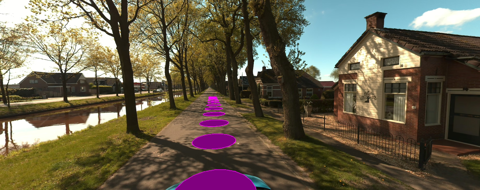
- Comprehensive Infrastructure Documentation: Creating detailed, 360° visual records perfect for asset inventories, condition assessments, and as-built documentation while reducing costly site revisits.
- Detailed 3D Visualizations: Providing rich visual data necessary to generate immersive and accurate 3D models and digital twins for comprehensive analysis and presentation.
- Continuous Construction Project Monitoring: Enabling frequent, detailed visual tracking of site progress, work quality, and adherence to plans throughout the entire project lifecycle.
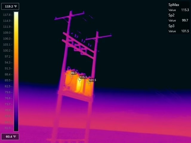
Revealing Hidden Infrastructure Issues with Thermal Imaging
Thermal imaging extensions unlock a new dimension of analysis, revealing critical information invisible to standard cameras. Adding thermal capabilities provides:
- Precise Hotspot Detection: Quickly identifies overheating electrical components, mechanical friction points, or other thermal anomalies indicative of potential failure.
- Enhanced Insulation Analysis & CO2 Assessment: Pinpoints areas of significant heat loss or gain in buildings, aiding energy efficiency improvements and sustainability efforts.
- Detection of Hidden Thermal Leakage: Reveals air leaks or insulation gaps in building envelopes or infrastructure not visible otherwise.
- Unparalleled Moisture Identification: Detects subsurface moisture intrusion in roofs, walls, or pavement structures through temperature differentials.
- Predictive Maintenance Capabilities: Enables proactive maintenance by identifying potential issues (like failing components or water ingress) before they cause major damage or downtime, allowing for scheduled repairs instead of emergency shutdowns.
Cross-Industry Applications & Use Cases
The combination of high-resolution visual and thermal data integrated with precise TRK positioning offers powerful benefits across various sectors:
- Infrastructure Monitoring: Maintain bridges, roads, railways, and utilities by visually assessing structural integrity and using thermal imaging to detect hidden weaknesses (e.g., delamination, water ingress) before they lead to costly closures or critical failures.
- Asset Management: Enhance safety and prevent costly failures in industrial plants or utility networks by identifying thermal anomalies that indicate imminent equipment failure. Efficiently monitor vast infrastructure networks and gain control over asset management.
- Real Estate & Building Management: Quickly identify energy inefficiencies in commercial or residential buildings for targeted retrofits, translating directly to operational savings. Support sustainability goals and generate detailed thermal documentation for renovation planning or property assessments.
Seamless Integration Without Disruption: Making Advanced Tech Practical
Simply attaching a camera is not enough. Horus specializes in creating truly integrated solutions. This approach ensures:
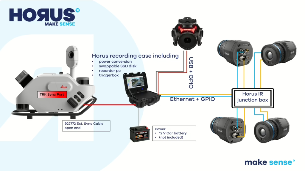
Ensuring Data Accuracy: Perfect Synchronization
Horus software ensures precise alignment between the TRK’s location data and every pixel in the captured imagery (visual and thermal).
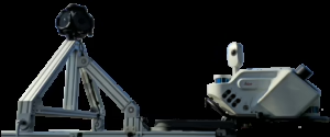
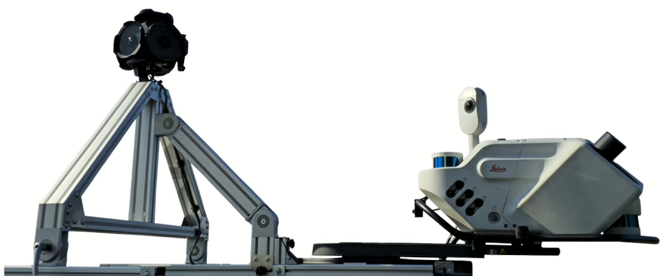
Built for the Field: Custom Mounting Solutions
The Horus team designs robust, practical, and often foldable mounting solutions specifically tailored to specific Leica TRK setups, ensuring stability and ease of use under operational conditions.
Effortless Operation: Streamlined Workflow & Data Handling
The Horus imaging system functions as a slave unit, controlled by the master TRK system, allowing for smooth, single-operator workflows. Since 2011, Horus has focused on integrating multi-vendor hardware into practical, reliable workflows. A key component is the proprietary Horus data logger:
- Safety Certified: ISOFIX certified and crash-tested for secure in-vehicle operation.
- Secure & Redundant: Features Dual Encrypted SSDs with automatic replication for high data security and reliability.
- NVIDIA-Powered Edge Computing: Incorporates powerful NVIDIA technology enabling significant edge computing capabilities and real-time processing directly on the logger.
- Real-Time Capabilities: This allows for demanding tasks like real-time image stitching, support for multiple image projection options, and real-time data streaming.
- Flexible Architecture: Built on a distributed systems architecture ready for additional on-edge workflows and API integration.
- Broad Compatibility: Supports multiple data formats, ensuring seamless integration with various post-processing environments.
This advanced on-board data handling reduces the burden on downstream systems, simplifies workflows, and potentially accelerates time-to-insight. Organizations leveraging these exclusive integrated systems report enhanced project deliverables.
With over 15 years of dedicated mobile mapping expertise, Horus delivers extensions that integrate effortlessly, maintaining productivity while enhancing deliverables with mature and reliable technology.
Future-Proofing Leica TRK Investments
There is no need to replace trusted Leica TRK systems to meet future demands. Horus extensions provide a cost-effective upgrade path, transforming existing equipment into a comprehensive reality capture platform. Enhance capabilities, offer more valuable services, and tackle complex projects with advanced visualization tools, all while leveraging familiar systems. The more comprehensive the visual and thermal data, the more thorough the assessment.
Conclusion
Meeting the evolving demands for comprehensive visual and thermal data is crucial for staying competitive in surveying and engineering. As has been shown, by strategically extending Leica TRK systems with advanced, seamlessly integrated imaging solutions like high-resolution panoramic and thermal cameras, powerful new capabilities are unlocked. This enhancement allows for more detailed assessments, predictive maintenance, and richer deliverables, ultimately future-proofing the investment and positioning organizations for success on increasingly complex projects. Move beyond basic data capture and unlock a new level of insight with existing Leica TRK systems.
Ready to Unlock Advanced Insights with Leica TRK?
Move beyond standard data limitations. Partner with Horus to integrate the visual and thermal intelligence needed for demanding projects and explore enhancement options:
- Initial Consultation: Connect with specialists to analyze specific project challenges and explore how advanced imaging capabilities can meet operational objectives.
Leverage the full potential of Leica TRK systems. Horus delivers field-tested expertise and proprietary technology, ensuring reliable integration and enhanced deliverables for complex projects globally.
Discover more
Related article