Reliability in the field: How to improve large-scale data acquisition
Reliability is a crucial factor in large-scale data acquisition projects. Without suitable equipment, projects risk delays, cost escalation, and data compromise.
In the world of construction, civil engineering, cartography, and surveying, accurate and reliable data acquisition is crucial. Large reality capturing companies often encounter significant challenges when collecting data on a grand scale, especially in demanding environments. Where their custom or homegrown mobile mapping systems now struggle to meet the demands of extensive data collection, lacking the sophistication needed for today’s requirements.
This blog post explores the common problems in large-scale data acquisition and introduces the Citymapper as a solution. We will explore how this advanced modular system provides the reliability and stability necessary for successful large-scale projects, and how it can increase productivity while minimizing costly interruptions.
- 15 minutes
Table of Contents
The challenges of
Large-Scale Data Acquisition
Large reality capturing companies face a range of challenges when conducting large-scale data acquisition projects.
System failures in harsh conditions pose a significant threat to equipment integrity. Extreme temperatures and dust can lead to overheating, while vibrations from poor road surfaces may damage sensitive components. These environmental factors can cause unexpected shutdowns or malfunctions, disrupting data collection efforts.
Data corruption and synchronization issues are another major concern. Unreliable connections between components can result in data loss or misalignment. Time-based matching, often used in less sophisticated systems, can lead to inaccuracies when correlating different data streams. Moreover, the process of data transfer itself can sometimes result in corruption or loss of valuable information.
Costly delays due to equipment outages have far-reaching consequences. When systems fail, teams often need to repeat data collection, significantly increasing project costs. Missed deadlines can lead to contractual penalties, and the overall productivity and efficiency of the operation decline. These setbacks can have a cascading effect on project timelines and budgets.
Inconsistent data quality over extended periods is a challenge that undermines the reliability of large-scale mapping projects. It’s difficult to maintain consistent results during long recording sessions, which can lead to quality differences between various parts of the project. This inconsistency can compromise the integrity of the entire dataset.
These challenges have a significant impact on business operations. Project costs escalate due to repeated data collection and extended timelines. Missed deadlines not only incur potential contractual penalties but can also damage relationships with clients. The reduction in productivity and efficiency affects the company’s bottom line. Perhaps most critically, inconsistent data quality can damage a company’s reputation, potentially leading to loss of future contracts.
A reliable solution
The Horus Citymapper
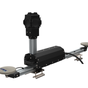
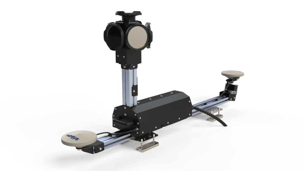
The CityMapper has been developed as a direct response to these challenges. It is a robust mobile mapping system, specifically designed for reliability and stability in demanding environments.
Improved data synchronization
and quality
Reduced downtime
and increased productivity
Consistent performance
over extended periods
Discover
The Key Features
The CityMapper has been developed as a direct response to these challenges. It is a robust mobile mapping system, specifically designed for reliability and stability in demanding environments.
Ruggedized Recording Unit
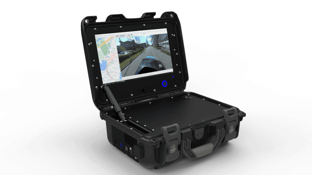
The CityMapper boasts a robust design that helps mitigate the effects of shocks and vibrations. At its core is a powerful recording, monitoring, and processing computer with a 13-inch screen. This ruggedized unit ensures that the system can withstand the harsh conditions often encountered in field operations, significantly reducing the risk of system failures due to environmental factors.
- mitigate harsh conditions
- 13 inch screen
Synchronized Hardware Triggering: One of the CityMapper’s standout features is its precise synchronization between GNSS/IMU and camera systems. It employs distance-based triggering, ensuring consistent and clean data collection. This approach eliminates many of the synchronization issues that plague less advanced systems, providing a level of data accuracy that is crucial for large-scale mapping projects.
Extended Operational Capacity: Designed for continuous use for up to 8 hours daily, the CityMapper is ideally suited for large-scale production projects. This extended operational capacity means fewer interruptions and more efficient use of field time, allowing teams to cover larger areas in a single session.
Advanced Battery Management System: The CityMapper incorporates an efficient system for handling power spikes and protecting against deep discharge. Compatible with standard 12V 100Ah batteries, this system ensures a stable power supply throughout extended recording sessions. The protection against deep discharge not only extends battery life but also prevents unexpected shutdowns that could compromise data collection.
Secure Data Storage and Transfer: The system features both 2TB external and internal disks, providing ample storage for large datasets. An integrated copy tool with CRC checks ensures secure data transfer, minimizing the risk of data corruption or loss during the critical phase of moving data from the field to the processing center.
Compact Transport
The CityMapper is designed with portability in mind. It can be transported in airline-safe, rugged cases – one for the roof unit and one for the recording unit. This feature facilitates easy deployment to project sites around the world, reducing logistical challenges and costs.
- Robust Transport Case (Airline-Safe)
Pre-calibrated Components: The Ladybug camera and GNSS come pre-calibrated, dramatically reducing setup time in the field. This feature ensures consistent calibration for accurate results across different deployments and minimizes the potential for human error in the setup process.
Simplified Startup Procedure: The CityMapper features an automated startup of all sensors and components, requiring minimal human intervention. This simplification reduces the potential for startup errors and ensures that the system is ready for data collection quickly and reliably.
These features directly address the challenges faced by reality capturing companies. They improve data synchronization and quality, reduce downtime, increase productivity, and ensure consistent performance over extended periods.
Case Study
Topocart's Project in Maracanaú-CE
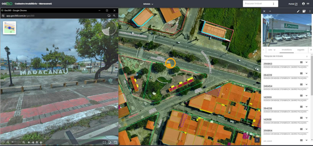
To demonstrate the effectiveness of the Citymapper in practice, let’s look at a large-scale project carried out by Topocart in Maracanaú-CE, Brazil. Located in Maracanaú-CE, Brazil, this comprehensive urban data collection project spanned 35 working days. The objective was to create a detailed digital map of the entire urban area, capturing a wide range of infrastructure and geographical features.
The use of the CityMapper allowed us to optimize production costs and the project’s timetable. Its interface and robustness guarantee us reliable and fast data. The associated software for processing the trajectory and obtaining precise coordinates allows us to take accurate measurements on the photos and obtain information quickly.” – Givanildo Silva, Director of Topocart
Data collected
103,000 buildings
22,000 road assets
The team successfully mapped 103,000 buildings, including 85,000 residential and 18,000 commercial structures. They documented 1,225 km of streets, identified 16,000 utility poles, and cataloged 6,000 streetlights. Additionally, they recorded the locations of 5,600 trees and mapped 45 km of bike lanes. This comprehensive dataset provides an unprecedented level of detail about the urban landscape of Maracanaú-CE.
Key Outcomes
The project resulted in several significant benefits for the city:
- A comprehensive property addressing system was developed, improving navigation and urban planning capabilities.
- E-commerce functionality in the area was enhanced through accurate delivery addresses and improved route planning.
- Tax management was optimized, with projections suggesting a potential 60% increase in tax revenue.
- Data transparency was increased through the implementation of public geoportals.
- The project helped attract investors by promoting the city’s industrial hub with accurate, up-to-date information.
This project illustrates how the CityMapper transforms large-scale data acquisition, resulting in more efficient processes and valuable outcomes for urban planning and management.
Technical Advantages
of the CityMapper contribute significantly to its reliability for large-scale data acquisition.
Increased uptime
Less downtime means more productive hours
- Ruggedized Recording Unit
- Pre-calibrated Sensors
Cost Efficiency
Fewer repetitions and faster project completion
- Secure Data Storage and Transfer
- Advanced Battery Management System
Ease of use
Reduced learning curve, minimal user errors
- Simplified Startup Procedure
- Synchronized data
Future Perspectives for Urban Planning and Management
The implementation of advanced mobile mapping systems like the Citymapper has far-reaching implications for the future of urban planning and management.
Data-Driven Decision Making: The accurate, up-to-date data provided by the CityMapper supports better-informed policy decisions. City planners can base their strategies on comprehensive, current information about urban infrastructure and geography.
Improved Infrastructure Planning: Comprehensive mapping of existing infrastructure enables more efficient maintenance and upgrade projects. For instance, the detailed inventory of utility poles and streetlights in Maracanaú-CE allows for more effective maintenance scheduling and upgrade planning.
Public Services Optimization: More efficient route planning for waste collection, public transport, and emergency services becomes possible with detailed 3D city models. Emergency services, for example, can use these models to plan the fastest routes, considering not just distance but also terrain and potential obstacles.
Promotion of Smart Cities: The integration of mapping data with IoT sensors enables real-time city monitoring. This data can support autonomous vehicles and smart mobility systems. In the future, traffic lights could automatically adjust their timing based on real-time traffic flow data collected by mobile mapping systems, reducing congestion and emissions.
Economic Growth and Investments: Accurate city models attract investors and support economic development. The comprehensive urban mapping in Maracanaú-CE, for instance, led to significant increases in tax revenue and attracted new businesses to the area.
Environmental Management and Sustainability: Detailed monitoring of green spaces and urban ecosystems supports climate adaptation strategies. City managers could use detailed tree inventories to plan green corridors, improving air quality and biodiversity in urban areas.
Enhanced Disaster Preparedness: The system enables rapid damage assessment after natural disasters, allowing for quicker and more effective response and recovery efforts.

The long-term impact of these developments is significant. Cities become more resilient and adaptive, the quality of life for urban residents improves, and urban environments become more sustainable and efficient. Moreover, the economic competitiveness of urban areas increases as they leverage this advanced technology to optimize their operations and attract investment.
Conclusion
The Citymapper represents a significant step forward in the world of large-scale data acquisition. Through its unique combination of robustness, reliability, and advanced technology, it offers a solution to the many challenges faced by reality capturing companies.
As cities worldwide continue to evolve and the need for detailed, up-to-date data increases, the role of advanced mobile mapping systems like the Citymapper will only become more critical. By investing in this technology, companies not only position themselves as leaders in their field but also contribute to the development of smarter, more efficient urban environments.
The future of urban planning and management is data-driven, and the Citymapper is at the forefront of this revolution. Whether it’s optimizing public services, improving infrastructure planning, or enhancing disaster preparedness, the accurate and comprehensive data provided by the Citymapper will play a crucial role in shaping the cities of tomorrow.
Are you ready to revolutionize your large-scale data acquisition projects? The CityMapper is here to help you meet the challenges of today and prepare for the opportunities of tomorrow.