
Speed Meets Quality: The CityMapper’s Promise
What if you do not have to choose? What if there was a way to collect high-quality GIS data at unprecedented speeds, all while enhancing safety and reducing costs?
In today’s fast-paced construction, civil engineering, and urban planning industries, you are likely facing a growing challenge. For asset management, asset inventory, and road inspection projects, traditional mapping methods – such as on-site visits, manual data collection, and total station use – while not entirely obsolete, become increasingly inefficient and risky as projects scale up or involve hazardous environments.
You know the dilemma all too well: Do you prioritize speed and risk compromising quality? Or maintain high standards at the cost of time and resources? Perhaps you have considered bringing fieldwork to the desk, weighing the safety risks of on-site data collection against project quality requirements.
What if you do not have to choose? What if there was a way to collect high-quality GIS data at unprecedented speeds, all while enhancing safety and reducing costs?
In this article, we will explore the reality capturing approach to GIS data collection that is changing the game for industry leaders. Whether you are looking to boost productivity, enhance safety, or stay ahead of tight deadlines, you will discover how cutting-edge technology is addressing key industry challenges and opening new possibilities for innovation.
- 12 minutes
Table of Contents

The challenges
Speed vs. Quality
In the world of GIS information gathering, professionals have long faced a dilemma: how to increase the speed of data collection without sacrificing the quality of the information gathered. Traditional mapping methods, which often require on-site visits and manual data collection, pose several challenges:
- Time-consuming processes that limit productivity
- Potential safety risks for field workers, especially in hazardous environments
- High labor costs associated with manual data collection
- Difficulty in scaling operations for larger projects
- Delayed decision-making due to slow data acquisition
As projects grow in scale and complexity, these challenges become increasingly pronounced, leading to a critical need for innovative solutions that can bridge the gap between speed and quality.
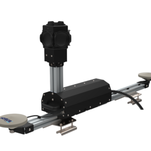
Introducing Mobile Mapping
Mobile mapping systems are designed to address the longstanding challenges in GIS data collection. Increasing time-to-insights by collecting street-level imagery and position data over a large span of distance.
At Horus, this has been our main focus since 2012. Adapting to the continuously changing space of technology advancement and customer requirements.
How it works
A mobile mapping systems operate by capturing reality while in motion, typically mounted on a vehicle. As you drive, it collects georeferenced imagery of the surrounding environment. This approach allows for rapid data collection across vast areas, dramatically reducing the time spent in the field while ensuring comprehensive coverage.
Key Features and Benefits
Our Horus Citymapper offers a turnkey experience with modular technology to meet specific needs. It boasts a range of features that set it apart from traditional mapping methods:
- High-speed data collection while driving
- Professional high-quality camera with global shutter
- Integrated GNSS/IMU for precise positioning
- Proprietary triggering hardware and recording software
- Perfect synchronization of positions and images
- Efficient data capture (configurable distance per image)
reduced field time
drastically
Enhanced safety
through remote inspection
Improved scalability
for large projects
Georeferenced imagery
immediately and High-quality
Increased productivity
and project completion rates
Revolutionizing Field Work
One of the most striking advantages of mobile mapping system is its ability to transform time-intensive and potentially dangerous fieldwork into a swift, safe process.
From months to weeks
Consider this scenario: an inspection project that traditionally took three months to complete can now be accomplished in just one week with a mobile mapping system. This dramatic reduction in field time not only accelerates project timelines but also minimizes exposure to potential hazards.
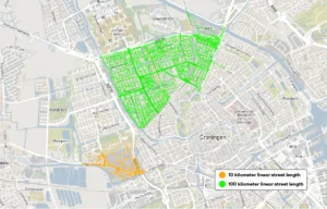
For example, a road inspection project covering 100 km might take a team of surveyors several weeks using traditional methods. With a mobile mapping system, the same distance could be covered in a single day, with high-quality data ready for analysis the next day.
Bringing the field to your desk
With mobile mapping, you can capture reality while driving and have imagery georeferenced. This means you can cover significantly more ground in less time, and then bring that fieldwork back to the office. Inspections that once required physical presence in potentially dangerous areas can now be conducted safely from the comfort of your workspace.
Comparison with traditional methods
To illustrate the advantages of mobile mapping systems, we compare them with traditional surveying methods in a few key areas. In terms of data collection speed, a traditional team might survey 5-10 km of road per day, whereas mobile mapping systems can easily cover 100-200 km per day. Regarding labor requirements, traditional methods typically require a team of 2-4 surveyors in the field, while mobile mapping often only needs an operator. Finally, in terms of data processing time, both traditional methods and mobile mapping systems take days to weeks for data compilation and processing.
Traditional method
- A team might survey 5-10 km of road per day.
- Typically requires a team of 2-4 surveyors in the field.
- Days to weeks for data compilation and processing.
Mobile mapping method
- Can easily cover 100-200 km per day.
- Often only needs an one operator.
- Near real-time data capture, with processing often completed in 24 hours.
Quality without compromise
Advanced Camera Technology
Integrating a professional high-quality camera with a global shutter. This means that images will not warp or distort while the vehicle is in motion, a common issue with cheaper cameras that use rolling shutters.
Precise Synchronization
Proprietary triggering hardware and recording software ensure perfect synchronization between positions and images, resulting in high-quality data that requires minimal post-processing.
Efficient Capture
The system is designed to take an image only after travelling a configured distance. This gives the camera time to “breathe” between shots and allows for higher travel speeds without compromising image quality.
The Horus CityMapper doesn’t just collect data faster – it collects better data, faster. By combining speed with uncompromising quality, it represents a true leap forward in GIS information gathering.
Real-World Applications
The capabilities of mobile mapping systems aren’t just theoretical – they’re being put to use in real-world scenarios with impressive results.
Airport Runway Inspection
Heijmans, a major European construction services business, uses the CityMapper to map the runways of Amsterdam Airport Schiphol. This application significantly reduces runway closure time while also cutting the economic costs associated with maintenance.
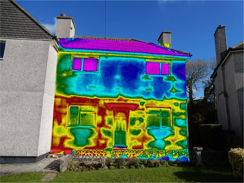
Decarbonization Efforts
IRT Surveys Ltd. employs the Horus CityMapper with a Thermal Infrared configuration to map over 10,000 homes per night. This data is crucial for decisions on domestic retrofitting, contributing to the goal of achieving warmer, healthier homes and reducing carbon footprints.
Forget 300 homes per night, we are setting our sights on 10,000. – Stewart Little from IRT Surveys Ltd-
Hidden Benefits: Beyond Speed and Quality
While the primary advantages of mobile mapping are clear, there are additional benefits that make it an even more compelling solution:
- Cost savings: Less time in the field translates to lower labor costs.
- Enhanced productivity: Complete more projects in the same timespan, boosting overall output.
- Improved decision-making: Faster access to high-quality data leads to better and quicker decisions.
- Increased safety: Minimize the need for on-site presence in potentially hazardous environments.
- Scalability: Easily adapt to projects of varying sizes without significant changes in methodology.
The Future of GIS Data Collection
As industries continue to evolve and the demand for rapid, accurate geospatial data grows, mobile mapping solutions like the Horus CityMapper are poised to become indispensable tools. The ability to gather high-quality GIS information quickly and safely not only improves current workflows but also opens up new possibilities for innovation in urban planning, infrastructure development, and environmental monitoring.
Conclusion
Mobile mapping represents a significant leap forward in the field of GIS data collection. By successfully marrying speed with quality, it addresses long-standing industry challenges and paves the way for more efficient, safe, and comprehensive mapping processes.
Whether you are looking to streamline large-scale projects, enhance worker safety, or simply stay ahead of the curve in geospatial technology, the CityMapper offers a powerful solution that can transform your approach to data collection. Ready
to Revolutionize Your GIS Data Collection? Discover how we can transform your mapping processes.
Contact us today for a free consultation and take the first step towards faster, safer, and more efficient data collection